Michael Weaver writes in with his own very thorough analysis of his own map!
This map is based on the (debatable and politically incorrect) premise that the United States may be too culturally diverse to hold itself together: ethnically diverse nations either stay together because one group forcefully subdues the others (as in the USSR), because different groups assimilate into a common culture (as in Brazil), or because different groups have been separated by clear geographical boundaries, as in Switzerland.
By this theory, the United States may have been held together earlier by domination, but without that, we have no secure bond. Our diverse groups aren’t likely to become a true melting pot the way Brazil has. If we want to avoid an eventual Yugoslavia-style breakup, that leaves imitating Switzerland; marking off clear boundaries for the major cultural, ethnic, and language groups in the United States. This can theoretically be done by looking at current demographics and accenting them even more, giving people some kind of incentive to move to where their group is predominant. Over time, (unlike in Switzerland) these regions would gradually become sovereign countries with homogenous, clearly defined cultures, which tend to be the most stable countries.
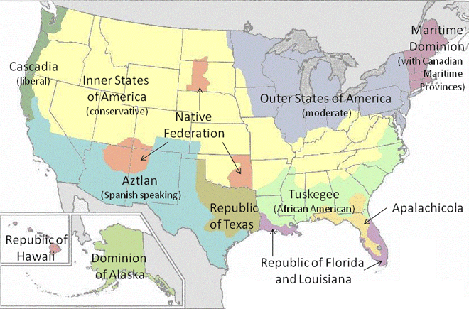
Of course some people wouldn’t want to move, but it should be a consolation that so many groups will have their own piece of land. African Americans get a broad swath of the South, where many already live. Hispanics, likewise, get much of the Southwest, where they have lived for centuries. The remainder of Texas that is not already dominated by Hispanics becomes the Republic of Texas, to satisfy the push for independence that is sure to arise there. To the South of the “Black Belt” is a small portion of the Deep South dominated by whites, which becomes sort of a de facto new Confederacy. Further south yet, the remainder of Florida joins with southern Louisiana to make a nation with a Creole flavor. The north continental US is split into four parts: the liberal West Coast; the conservative Heartland; the moderate Great Lakes and Mid-Atlantic, and New England, which may join with Canada’s Maritime Provinces. Alaska and Hawaii also become independent.
Since my concern was making culturally homogenous nations, I didn’t respect current state boundaries much. I also didn’t pay much attention to county lines, transportation routes, or rivers. I mostly went by current demographics, and even my knowledge of that is far from exhaustive, so the map is very much open to criticism (as is the premise behind it). Still, should the need arise, I think it would be a good starting point to make a plan for the United States to go out with dignity, and leave behind stable, secure states in its place.